CUSEC maintains a variety of maps, geographic information systems (GIS), and data sets. These products provide information about potential earthquake hazards and risks to the public and communities. They also provide emergency managers and planners with enhanced information sharing and plan development capabilities. Use the links below to browse through our GIS and information sharing products. You can also visit cusec.maps.arcgis.com to view content.
The Regional Information Sharing Platform (RISP) is a cloud-based tool that provides emergency managers access to critical information and decision support tools. The RISP is based on a system of systems approach, using cloud-based technologies to provide accurate, timely data on Community Lifelines, Essential Elements of Information (EEIs), maps, and analytical tools. Managed by CUSEC, the RISP aggregates information and data from multiple sources including state, federal, and private sector partners.

CUSEC Regional Information Sharing Platform (RISP)
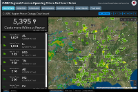
Regional Common Operating Picture Dashboard Series
In 2015, CUSEC and its Member States, with major funding support from the Delta Regional Authority, partnered to implement the first phase of a new regional information sharing project using geographic information systems (GIS) and other emerging technology to support emergency response, recovery, and community resiliency. Integral to this project is the CUSEC Regional Common Operating Platform (RCOP)— a cloud-based GIS and information management and sharing platform.
The CUSEC RCOP was established to provide an eight-state operational view of essential elements of information (EEIs) such as power outages, transportation infrastructure, critical facility status, shelter status, and more.
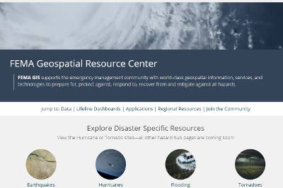
FEMA Geospatial Resource Center
FEMA GIS supports the emergency management community with world-class geospatial information, services, and technologies to prepare for, protect against, respond to, recover from and mitigate against all hazards. The FEMA Geospatial Resource Center provides resources for the emergency management community.

GeoPlatform.Gov
The GeoPlatform was developed by the member agencies of the Federal Geographic Data Committee (FGDC) through collaboration with partners and stakeholders. The target audience for the GeoPlatform includes Federal agencies, State, local, and Tribal governments, private sector, academia, and the general public.

Esri Disaster Response Program GIS Resource Hub
The Esri Disaster Response Program GIS Resource Hub includes templates, data, and live feeds to support response efforts.